class: center, middle, inverse, title-slide # Analyse d’images raster ## (et télédétection) ### Malika Madelin <br><a href="mailto:malika.madelin@u-paris.fr" class="email">malika.madelin@u-paris.fr</a> ### 1/7/2021 --- class: center middle background-image: url("fig/Couv.png") background-size: cover # Les images raster <!-- D'office sous xaringanthemer --> <!-- Lancement des librairies --> ---  [Landsat NASA](https://landsat.gsfc.nasa.gov/sites/landsat/) --- .pull-left[ <img src="SIGR2021_raster_MM_files/figure-html/unnamed-chunk-1-1.png" width="100%" /> ] .pull-right[ <img src="SIGR2021_raster_MM_files/figure-html/unnamed-chunk-2-1.png" width="100%" /> ] -- class:center **qq mots sur le poids des images...** -- <center><img src="fig/datatype.png" height="200px" /></center> [dataType {raster}](https://search.r-project.org/CRAN/refmans/raster/html/dataType.html) --- ## Intérêts/avantages .pull-left[ - structure des données ~ simple, <br>topologie implicite ] --- ## Intérêts/avantages .pull-left[ - structure des données ~ simple, <br>topologie implicite - information spatiale **continue**, <br> souvent récoltée **à distance** et **globalement** ] <center><img src="fig/Deforestation.png"></center> --- ## Intérêts/avantages  --- ## Intérêts/avantages .pull-left[ - structure des données ~ simple, <br>topologie implicite - information spatiale **continue**, <br> souvent récoltée **à distance** et **globalement** - information figée dans le **temps** <br>+ répétitivité ] --- ## Intérêts/avantages  --- ## Intérêts/avantages .pull-left[ - structure des données ~ simple, <br>topologie implicite - information spatiale **continue**, <br> souvent récoltée **à distance** et **globalement** - information figée dans le **temps** <br>+ répétitivité - caractère **multispectral** (bandes/couches), - parfois **multidimensionnel** (hauteur, profondeur / temps) ] .pull-right[ <center>Composition colorée, Sentinel 2A, 28/5/21</center> <img src="SIGR2021_raster_MM_files/figure-html/unnamed-chunk-3-1.png" width="100%" /> ] --- ## Intérêts/avantages .pull-left[ - structure des données ~ simple, <br>topologie implicite - information spatiale **continue**, <br> souvent récoltée **à distance** et **globalement** - information figée dans le **temps** <br>+ répétitivité - caractère **multispectral** (bandes/couches), - parfois **multidimensionnel** (hauteur, profondeur / temps) - plusieurs thématiques possibles pour une même image - relative facilité des traitements ] .pull-right[  Extrait d'une présentation de Madelin et Dupuis, 2018 ] --- ## Intérêts/avantages .pull-left[ - structure des données ~ simple, <br>topologie implicite - information spatiale **continue**, <br> souvent récoltée **à distance** et **globalement** - information figée dans le **temps** <br>+ répétitivité - caractère **multispectral** (bandes/couches), - parfois **multidimensionnel** (hauteur, profondeur / temps) - plusieurs thématiques possibles pour une même image - relative facilité des traitements ] .pull-right[  Extrait d'une présentation de Madelin et Dupuis, 2018 ] ... mais **volume** des données non négligeable --- ## Par rapport à la reproductibilité - souvent homogénéité dans la production des données (produits globaux), harmonisation "minime" -- <center><img src="fig/Diapo_CollCIST.png" height="370px" /></center> <center>Extrait d'une présentation de Pécout <it>et al</it>, 2016</center> <center>Projet Grandes métropoles</center> --- ## Par rapport à la reproductibilité - souvent homogénéité dans la production des données (produits globaux), harmonisation "minime" - données souvent accessibles <br> _via_ des **plateformes** ([Earth Explorer](), [Sentinel Hub](), [GEE](), ...) <br> <center><img src="fig/plateformes2.png" height="400px" /></center> --- ## Par rapport à la reproductibilité - souvent homogénéité dans la production des données (produits globaux), harmonisation "minime" - données souvent accessibles <br> _via_ des **plateformes** ([Earth Explorer](), [Sentinel Hub](), [GEE](), ...) <br> _via_ des **outils d'extraction** pour certaints formats (ncdf) <br> _via_ certains packages R (`{raster}`, `{modisTSP}`, `{sen2r}`...) -- - de nombreux formats ouverts<br> [geotiff](https://www.ogc.org/standards/geotiff) / [jp2](https://fr.wikipedia.org/wiki/JP2) / asc / [gpkg-raster](https://gdal.org/drivers/raster/gpkg.html) / [coverageJSON](https://covjson.org/...)<br> ([ncdf](https://www.unidata.ucar.edu/software/netcdf/) / hdf /grib...) --- 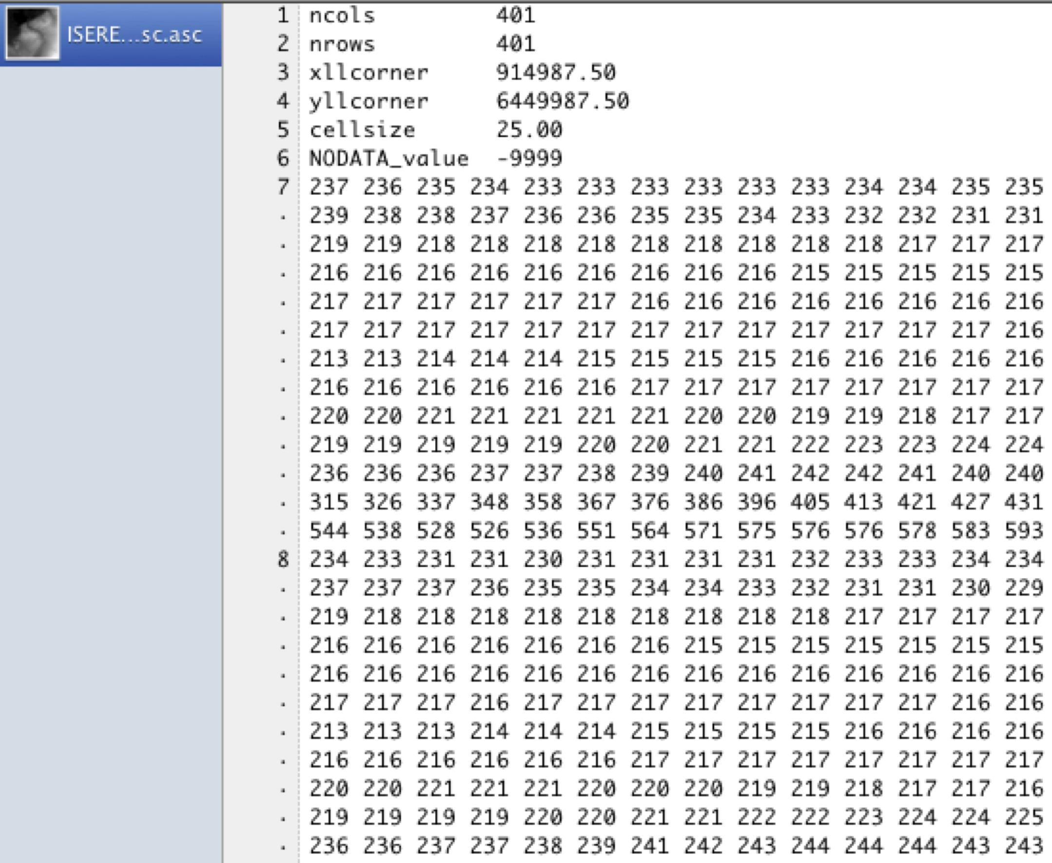 (BD Alti 25m) --- ## Par rapport à la reproductibilité - souvent homogénéité dans la production des données (produits globaux), harmonisation "minime" - données souvent accessibles <br> _via_ des **plateformes** ([Earth Explorer](), [Sentinel Hub](), [GEE](), ...) <br> _via_ des **outils d'extraction** pour certaints formats (ncdf) <br> _via_ certains packages R (`{raster}`, `{modisTSP}`, `{sen2r}`...) - de nombreux formats ouverts<br> [geotiff](https://www.ogc.org/standards/geotiff) / [jp2](https://fr.wikipedia.org/wiki/JP2) / asc / [gpkg-raster](https://gdal.org/drivers/raster/gpkg.html) / [coverageJSON](https://covjson.org/...)<br> ([ncdf](https://www.unidata.ucar.edu/software/netcdf/) / hdf /grib...) -- <center><img src="fig/ncdf.png" height="150px"></center> [UCAR](http://www.narccap.ucar.edu) --- ## Par rapport à la reproductibilité .pull-left[ <center>Modèle numérique d'élévation <br>SRTM - Argentine</center> <img src="SIGR2021_raster_MM_files/figure-html/unnamed-chunk-4-1.png" width="100%" /> ] .pull-right[ ```r dim(srtm) ``` ``` ## [1] 6000 6000 1 ``` Export `writeRaster()` selon 3 formats et calcul de la taille des fichiers résultants `file.size()` <table> <thead> <tr> <th style="text-align:left;"> Type du fichier </th> <th style="text-align:right;"> Taille en Mo </th> </tr> </thead> <tbody> <tr> <td style="text-align:left;"> ascii </td> <td style="text-align:right;"> 155.7 </td> </tr> <tr> <td style="text-align:left;"> tif </td> <td style="text-align:right;"> 60.6 </td> </tr> <tr> <td style="text-align:left;"> gpkg </td> <td style="text-align:right;"> 48.7 </td> </tr> </tbody> </table> ] --- ## Par rapport à la reproductibilité - souvent homogénéité dans la production des données (produits globaux), harmonisation "minime" - données souvent accessibles <br> _via_ des **plateformes** ([Earth Explorer](), [Sentinel Hub](), [GEE](), ...) <br> _via_ des **outils d'extraction** pour certaints formats (ncdf) <br> _via_ certains packages R (`{raster}`, `{modisTSP}`, `{sen2r}`...) - de nombreux formats ouverts<br> [geotiff](https://www.ogc.org/standards/geotiff) / [jp2](https://fr.wikipedia.org/wiki/JP2) / asc / [gpkg-raster](https://gdal.org/drivers/raster/gpkg.html) / [coverageJSON](https://covjson.org/...)<br> ([ncdf](https://www.unidata.ucar.edu/software/netcdf/) / hdf /grib...) - des libraires C, communes à plusieurs logiciels/langages (GDAL, ...) --- ## Sous R, 3 packages "phares" .left-column[ [`{raster}`](https://cran.r-project.org/web/packages/raster/) <br>  ] .right-column[ .pull-left[ <center><img src="fig/raster.png" /></center> ] .pull-right[ Documentation de 249p. (18/6/2018), avec en préambule, une organisation par blocs : <br><br> 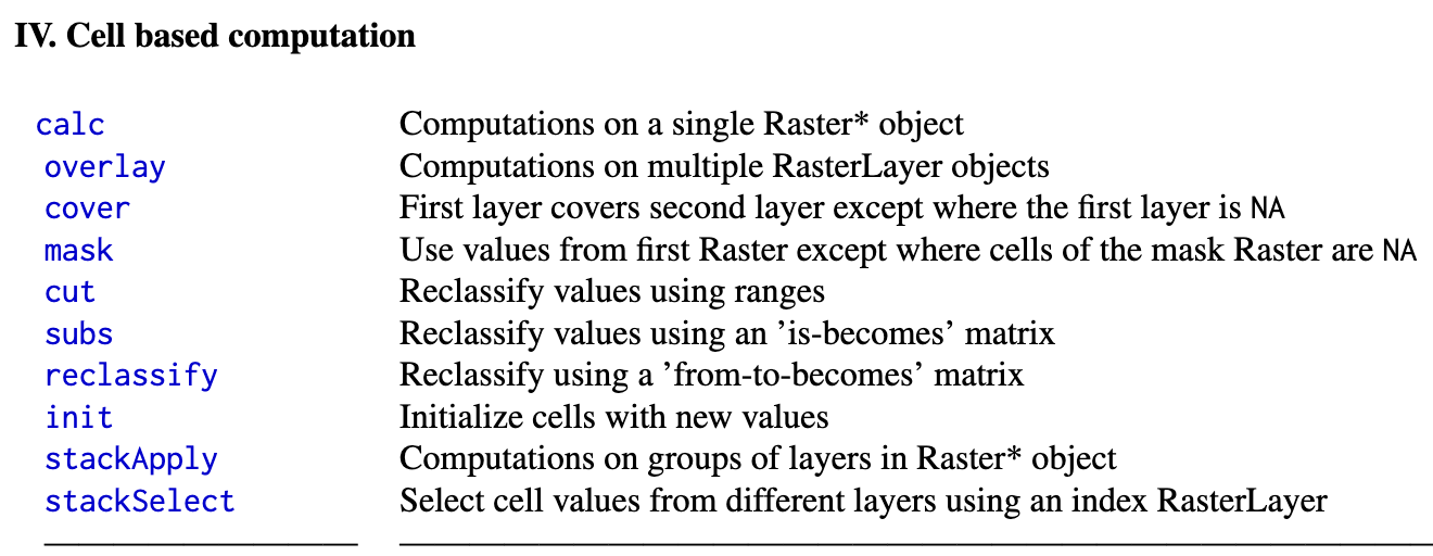 ] ] --- ## Sous R, 3 packages "phares" .left-column[ [`{stars}`](https://cran.r-project.org/web/packages/stars/index.html) <br>  ] .right-column[ 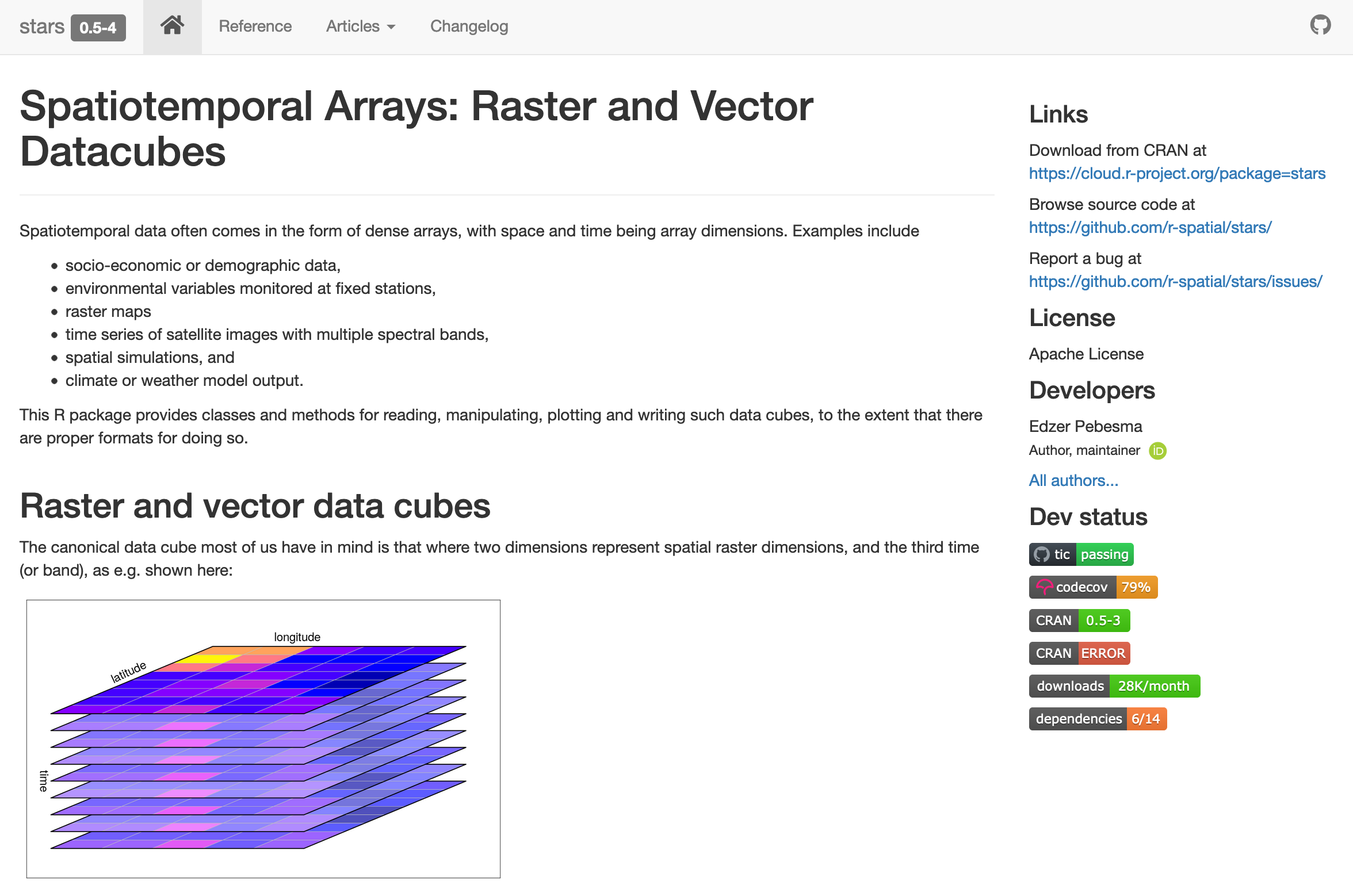 ] --- ## Sous R, 3 packages "phares" .left-column[ [`{terra}`](https://cran.r-project.org/web/packages/terra/) <br>  ] .right-column[ .pull-left[ <center><img src="fig/terra.png" /></center> ] .pull-right[ Documentation de 218p. (20/6/2018), avec en préambule, une organisation par blocs : <br><br> 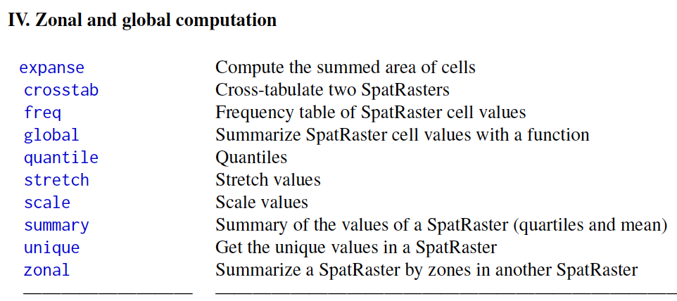 ] ] --- ## Sous R, 3 packages "phares" La "popularité" des 3 packages, à partir du nombre de téléchargements <img src="SIGR2021_raster_MM_files/figure-html/unnamed-chunk-8-1.png" width="100%" /> --- ## Sous R, 3 packages "phares" Comparatif du [blog de seascape](https://www.seascapemodels.org/rstats/2021/06/01/STARS.html) : "So terra was about 8.5 times faster than raster and stars was about 3 times faster than terra (so about 26 times faster than raster)." Pour les opérations réalisées... --  [Krzysztof Dyba - kadyb](https://github.com/kadyb/raster-benchmark) --- class: inverse center middle # Les traitements <br>sur les images raster --- # Lecture des fichiers raster sous R .left-column[  ] .right-column[ ```r file.size("data/Sentinel/Sen2_zoom_TCI_280521_10m.tif") * 10^-3 # (en Ko) ``` ``` ## [1] 183.038 ``` ```r GDALinfo("data/Sentinel/Sen2_zoom_TCI_280521_10m.tif") ``` ``` ## rows 218 ## columns 279 ## bands 3 ## lower left origin.x 632850.6 ## lower left origin.y 5093260 ## res.x 9.984642 ## res.y 9.984154 ## ysign -1 ## oblique.x 0 ## oblique.y 0 ## driver GTiff ## projection +proj=utm +zone=30 +datum=WGS84 +units=m +no_defs ## file data/Sentinel/Sen2_zoom_TCI_280521_10m.tif ## apparent band summary: ## GDType hasNoDataValue NoDataValue blockSize1 blockSize2 ## 1 Byte FALSE 0 9 279 ## 2 Byte FALSE 0 9 279 ## 3 Byte FALSE 0 9 279 ## apparent band statistics: ## Bmin Bmax Bmean Bsd ## 1 0 255 NA NA ## 2 0 255 NA NA ## 3 0 255 NA NA ## Metadata: ## AREA_OR_POINT=Area ``` ] --- # Lecture des fichiers raster sous R Avec [`{raster}`](https://cran.r-project.org/web/packages/raster/) ```r r <- raster("data/Sentinel/Sen2_zoom_TCI_280521_10m.tif") r ``` ``` ## class : RasterLayer ## band : 1 (of 3 bands) ## dimensions : 218, 279, 60822 (nrow, ncol, ncell) ## resolution : 9.984642, 9.984154 (x, y) ## extent : 632850.6, 635636.3, 5093260, 5095437 (xmin, xmax, ymin, ymax) ## crs : +proj=utm +zone=30 +datum=WGS84 +units=m +no_defs ## source : Sen2_zoom_TCI_280521_10m.tif ## names : Sen2_zoom_TCI_280521_10m ## values : 0, 255 (min, max) ``` ```r object.size(r) ; inMemory(r) ``` ``` ## 14608 bytes ``` ``` ## [1] FALSE ``` --- # Lecture des fichiers raster sous R Avec [`{raster}`](https://cran.r-project.org/web/packages/raster/) ```r r_brick <- brick("data/Sentinel/Sen2_zoom_TCI_280521_10m.tif") r_brick ``` ``` ## class : RasterBrick ## dimensions : 218, 279, 60822, 3 (nrow, ncol, ncell, nlayers) ## resolution : 9.984642, 9.984154 (x, y) ## extent : 632850.6, 635636.3, 5093260, 5095437 (xmin, xmax, ymin, ymax) ## crs : +proj=utm +zone=30 +datum=WGS84 +units=m +no_defs ## source : Sen2_zoom_TCI_280521_10m.tif ## names : Sen2_zoom_TCI_280521_10m.1, Sen2_zoom_TCI_280521_10m.2, Sen2_zoom_TCI_280521_10m.3 ## min values : 0, 0, 0 ## max values : 255, 255, 255 ``` ```r object.size(r_brick) ``` ``` ## 15192 bytes ``` --- # Lecture des fichiers raster sous R Avec [`{terra}`](https://cran.r-project.org/web/packages/terra/) ```r t <- rast("data/Sentinel/Sen2_zoom_TCI_280521_10m.tif") t ``` ``` ## class : SpatRaster ## dimensions : 218, 279, 3 (nrow, ncol, nlyr) ## resolution : 9.984642, 9.984154 (x, y) ## extent : 632850.6, 635636.3, 5093260, 5095437 (xmin, xmax, ymin, ymax) ## coord. ref. : +proj=utm +zone=30 +datum=WGS84 +units=m +no_defs ## source : Sen2_zoom_TCI_280521_10m.tif ## red-grn-blue: 1, 2, 3 ## names : Sen_1, Sen_2, Sen_3 ``` ```r object.size(t) ``` ``` ## 1304 bytes ``` --- # Lecture des fichiers raster sous R Avec [`{stars}`](https://cran.r-project.org/web/packages/stars/index.html) ```r s <- read_stars("data/Sentinel/Sen2_zoom_TCI_280521_10m.tif") s ``` ``` ## stars object with 3 dimensions and 1 attribute ## attribute(s): ## Min. 1st Qu. Median Mean 3rd Qu. Max. ## Sen2_zoom_TCI_280521_10m.tif 10 30 51 57.15503 64 255 ## dimension(s): ## from to offset delta refsys point values x/y ## x 1 279 632851 9.98464 WGS 84 / UTM zone 30N FALSE NULL [x] ## y 1 218 5095437 -9.98415 WGS 84 / UTM zone 30N FALSE NULL [y] ## band 1 3 NA NA NA NA NULL ``` ```r object.size(s) ``` ``` ## 1471360 bytes ``` --- # Lecture des fichiers raster sous R ** Opérations classiques après lecture / création d'un raster : ** .left-column[ - dimensions - étendue - résolution(s) - projection ] --- # Lecture des fichiers raster sous R ** Opérations classiques après lecture / création d'un raster :** .left-column[ - dimensions - étendue - résolution(s) - projection - visualisation (rapide) - histogramme des valeurs - parfois améliorations des contrastes <br> ( _stretching_ ) ] .right-column[ .pull-left[  ] .pull-right[ <img src="SIGR2021_raster_MM_files/figure-html/unnamed-chunk-14-1.png" width="100%" /> À partir de Sentinel B08 ] ] --- # Modifications de la zone d'étude -- ### • (re)projection  Source : Centre Canadien de Télédétection --- # Modifications de la zone d'étude ### • (re)projection `raster:projectRaster()` / `terra:project()` / `stars:st_transform()` -- <center><img src="fig/stars_projection.png" height="300px"></center> [avec `{stars}`](https://cran.r-project.org/web/packages/stars/vignettes/stars5.html) --- # Modifications de la zone d'étude ### • découpage et masque ( _crop & mask_ ) ```r # on reprend la compo colorée de Sentinel 2 (sen) # ajout du buffer 30 km autour d'ici (cf. présentation de Ronan) buf <- st_read(dsn = paste0("data/KeynoteRonan/oleron.gpkg"), layer = "cnrsBuf", quiet = TRUE) buf <- st_transform(buf, crs(sen)) # pour avoir le même CRS buf <- vect(buf) # transformation de l'objet sf en object SpatVector (terra) # découpage (selon l'étendue) sen_Oleron_crop <- crop(sen, buf) # masque sen_Oleron_mask <- mask(sen, buf) ``` --- # Modifications de la zone d'étude ### • découpage et masque ( _crop & mask_ ) .left-column[ <img src="SIGR2021_raster_MM_files/figure-html/unnamed-chunk-16-1.png" width="100%" /> ] --- # Modifications de la zone d'étude ### • découpage et masque ( _crop & mask_ ) .left-column[ <img src="SIGR2021_raster_MM_files/figure-html/unnamed-chunk-17-1.png" width="100%" /> ] .right-column[ .pull-left[ <center> _CROP_ <center> <img src="SIGR2021_raster_MM_files/figure-html/unnamed-chunk-18-1.png" width="100%" /> ] .pull-right[ <center> _MASK_ </center> <img src="SIGR2021_raster_MM_files/figure-html/unnamed-chunk-19-1.png" width="100%" /> ] ] --- # Modifications de la zone d'étude ### • agrégation / désagrégation  --- # Modifications de la zone d'étude ### • Fusion _merge_ et mosaïque 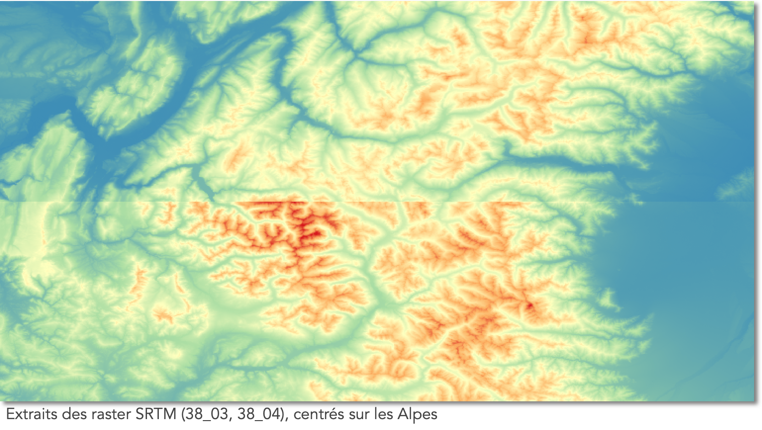 --- # Opérations locales 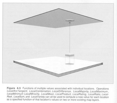 Source : J. Mennis <!-- Figure d'un ancien cours de J. Mennis, qui reprend a priori une figure d'un ouvrage, mais pas d'info sur lequel --> --- # Opérations locales ## • Reclassification ( _reclassify_ ) Des 44 postes les plus fins de la nomenclature CLC2018 aux 5 principaux 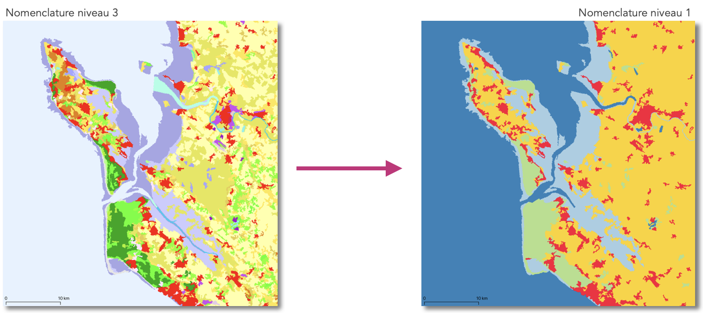 --- # Opérations locales ## • Création de "masque raster" (1/0) De la lecture des valeurs spectrales à une typologie eau / pas eau <img src="SIGR2021_raster_MM_files/figure-html/unnamed-chunk-20-1.png" width="100%" /> Autre possibilité : `r[r>500] <- NA` --- # Opérations locales ## • Calcul matriciel / Calculatrice raster La gestion des valeurs manquantes : `r[r[]== -9999] <- NA` `r[is.na(r)] <- 0` --- # Opérations locales ## • Calcul matriciel / Calculatrice raster <center> <img src="fig/OpLoc_Clim.png" height="300px"></center> Source : [soils.org](http://soils.org) --- # Opérations locales ## • Calcul matriciel / Calculatrice raster Calcul d'un NDVI ```r B04 <- rast("data/Sentinel/T30TXR_20210528T105621_B04_10m.jp2") B08 <- rast("data/Sentinel/T30TXR_20210528T105621_B08_10m.jp2") dim(B08) ``` ``` ## [1] 10980 10980 1 ``` ```r NDVI <- (B08 - B04) / (B08 + B04) ``` --- # Opérations locales ## • Calcul matriciel / Calculatrice raster ```r plot(NDVI) ``` <img src="SIGR2021_raster_MM_files/figure-html/unnamed-chunk-22-1.png" width="100%" /> --- # Opérations locales ## • Calcul matriciel / Calculatrice raster Avec `{terra::calc()}` --- # Opérations locales ## • Calcul matriciel / Calculatrice raster Autres exemples : pour comparer 2 raster, pour voir la corrélation entre 2 raster, etc. => opérations souvent utilisées pour des intégrations temporelles et pour des calculs d'indices (ex : superposition pondérée) ... mais attention à la cohérence spatiale entre les couches raster --- # Opérations focales 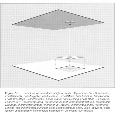 Source : J. Mennis --- # Opérations focales ## • Filtres (passe-bas ~ lissage, passe-haut, Laplacien...) <center>Extrait de la BD Alti IGN 25m • Médiane sur une fenêtre de 3x3</center> .pull-left[ <img src="SIGR2021_raster_MM_files/figure-html/unnamed-chunk-23-1.png" width="100%" /> ] .pull-left[ <img src="SIGR2021_raster_MM_files/figure-html/unnamed-chunk-24-1.png" width="100%" /> ] --- # Opérations focales ## • Autour des raster d'altitude ```r pente <- terrain(srtm, "slope", neighbors = 4, # 4 ou 8 pixels autour pris en compte unit = "degrees") sp::spplot(pente, col.regions=grey.colors(100, rev = TRUE)) ``` <img src="SIGR2021_raster_MM_files/figure-html/unnamed-chunk-25-1.png" width="100%" /> --- # Opérations zonales ou globales  Source : J. Mennis --- # Opérations zonales ou globales ```r class(r_zoom) ``` ``` ## [1] "SpatRaster" ## attr(,"package") ## [1] "terra" ``` ```r head(values(r_zoom)) ``` ``` ## U2018_CLC2018_V2020_20u1 ## [1,] 24 ## [2,] 24 ## [3,] 24 ## [4,] 24 ## [5,] 24 ## [6,] 24 ``` ```r # ou r_zoom[] ``` --- # Opérations zonales ou globales ```r table(r_zoom[])*100/ncell(r_zoom[]) ``` ``` ## ## 2 18 24 25 39 44 ## 12.962963 12.962963 39.351852 12.500000 9.722222 12.500000 ``` --- # Opérations zonales ou globales Aussi avec `cellStats(r, stat=mean)`, `minValues(r)`... • Statistiques zonales (Z = raster ou vecteur) : `mon_sf$newcol <- extract(r, mon_sf)` # pour sf ponctuel `mon_sf$newcol <- extract(r, mon_sf, fun=mean, df=TRUE)` # pour sf polygones `mon_sf$newcol <- extract(r, mon_sf, buffer = 100, fun=mean, df=TRUE)`# pour sf ponctuel avec buffer ---  ---  Madelin, Dupuis, 2020 --- # Les traitements des images sat - amélioration pour aider à l'interprétation -- - traitements physiques (signal -> propriété physique) -- - réalisation de zonages --- # Les traitements des images sat  Caloz, Collet, 2001 --- # Les traitements des images sat Exemple à partir des 4 bandes de Sentinel 10m (B/V/R/PIR) ```r l <- list.files("data/Sentinel/", pattern = "T30TXR_20210528T105621_B", full.names=TRUE) r <- rast(l) ext <- c(632850.5598, 635636.2748, 5093260.008, 5095436.5536) r <- crop(r, ext) ``` --- # Cartographie, visualisation - `{raster}` ou `{raster}`, avec `plot()` - `{stars}` (qui gère bien les raster lourds, _via_ une agrégation de l'information en amont) - `{sp}` avec `spplot()` - `{rasterVis}`, avec `levelplot()` - `{leaflet}` avec `addRasterImage()`(pb : projection, raster lourds) - `{tmap}` avec `tm_raster()` - `{rayshader}` - `{mapview}`... --- # Ressources Hijmans R. (2019). [Spatial Data Science with R](https://rspatial.org/) Lovelace R., Nowosad J. & Muenchow J. (2020). [Geocomputation with R](https://geocompr.robinlovelace.net) Pebesma E. & Bivand R. (2019). [Spatial Data Science with applications in R](https://www.r-spatial.org/book) Ghosh A. & Hijmans R. [Remote Sensing Image Analysis with R](https://rspatial.org/terra/rs/rs.pdf) les blogs, Rpubs, RZine, les stackoverflow & Co.